Wari and Tiwanaku: Friends or Foes?
During the Middle Horizon, from A.D. 500 to 1000, the polities of Wari and Tiwanaku dominated much of the Andean landscape. Archaeological evidence shows that both polities shared commonalities in ideology and certain aspects of stylistic expression, however, they differed in their use of the geographic landscape, architectural style, ceramic production, and social and political organization. The nature of the relationship between the Wari and Tiwanaku polities is one that has provoked scholarship for decades. Were the polities of Wari and Tiwanaku in conflict or was there a diplomatic coexistence (Owen 1994)? An overview of the differences between the Wari and Tiwanaku polities and an analysis of archaeological evidence from the shared geographic region, the Wari/Tiwanaku frontier, may shed light and bring us closer to an answer of this question.

Above image from: Andean Art. (2014). Essential Humanities. Retrieved from http://www.essential-humanities.net/world-art/andean/
The
geographic region occupied by the Wari encompasses
the Ayacucho Valley (Isbell and Vranich 2004). The terrain is an uneven
topography of deep ravines and high mountain peaks (Isbell and Vranich 2004).
The sky appears close to settlements and offers sweeping panoramic views of the
land (Isbell and Vranich 2004). The land is fertile and suitable for large
scale agriculture (Isbell and Vranich 2004). By contrast, the geographic region
occupied by Tiwanaku is a much higher, flat altiplano that surrounds the Lake
Titicaca Basin (Isbell and Vranich 2004). The entirety of the area is
surrounded by mountains, creating a retreating skyline (Isbell and Vranich 2004). The high altitude of
the Tiwanaku region makes the land unsuitable for large scale agriculture, but
the tall grasses known to the region would seasonally attract herds of llamas
and alpacas (Isbell and Vranich 2004).
The Wari and Tiwanaku incorporated their geographic areas into their architecture in very different ways. Wari architecture exhibits a uniformity that remains the same regardless of topography, and they also had little to no colossal monuments (Nash and Williams 2005). Wari provincial centers exhibit D-shaped structures and an architectural pattern known as orthogonal (Isbell and Vranich 2004). Wari structures usually consisted of double-faced stone masonry or adobe superstructures (Nash and Williams 2005). Wari settlements were complemented by comprehensive agricultural systems of terraces and cultivated slopes irrigated by canals (Nash and Williams 2005). The Wari implemented symbolism into their architecture to convey different levels of political hierarchy, which can be used to assess the status and rank of spatial settings (Nash and Williams 2005). The Tiwanaku polity is noted for its monumental constructions and elaborate stone stelae

(Janusek 2002). Sunk-in courtyards were a unique
characteristic common throughout the Tiwanaku polity (Nair and Protzen 2000). The
site is thought to have been developed in an east-west orientation, a solar
path that guided the urban layout of Tiwanaku (Nair and Protzen 2000). The
monumental architecture of Tiwanaku included massive stone platforms, pyramids,
and gateways that were possibly covered with burnished metal sheets (Isbell and
Vranich 2004). Although originally thought to be primarily a ceremonial center,
it has been proposed by Ponce Sanginès in the 1960’s, as well as recent
archaeologists, that Tiwanaku developed into an urban center including
residential structures made from earthen brick that eroded into the land
(Janusek 2002).

Image of Tiwanaku monumental architecturefrom:Trekearth.com; courtesy of evaldivia_98
Ceramic
production of the Wari and Tiwanaku polities differs as well. Although both
polities share similar iconographic traditions depicting the Front Faced Deity
or the Staff god, the style and form
of
ceramics differ vastly between the regions (Williams 2001). Wari ceramics vary
from finely to casually made, and elaborate to simply decorated (Owen 2007).
Trademarks of Wari ceramics include polychrome color schemes, elaborate
patterning, smooth burnishing, and iconography depicting secular and
supernatural themes (Owen 2007).
Tiwanaku ceramics have been divided into five distinct phases and retain
standardization throughout these phases (Janusek 2002). Characteristics of
Tiwanaku ceramics include bulbous-bottom vases, wide-rimmed escudillas, and
libation bowls (Janusek 2002). Although red slip is considered the hallmark of
Tiwanaku ceramics, there was a range in color slips from light brown to black,
with deep incising and rough burnishing (Janusek 2002). Many Tiwanaku ceramics were decorated with
supernatural imagery (Janusek 2002).


Above right image Wari style ceramics fromFlicker.com;courtesy of zug55; acove left image of Tiwanaku style ceramics from dss.ucsd.edu;courtesy of Paul Goldstein
Wari
political organization was structured in a hierarchal manner, the main seat of
administrative power being the Wari capital and its surrounding valleys (Jennings
2006). The Wari relied on satellite sites outside the capital to oversee
administration of local economies and procure resources, these sites were distinctive of Wari
architectural style (Jennings 2006). Control in these administrative sites
outside the Wari capital was determined chiefly by state interests,
organizational matters, and local surroundings (Jennings 2006). Elites held
authority over labor production and access to resources, and when resources
were procured they were sent to the capital (Jennings 2006). In return, the
capital provided elite goods and generous hospitality to the local elites and
leaders (Jennings 2006). Through collusion with local leaders, organization of
economic structures tailored to local areas, elaborate feasts, and the threat
of force, the Wari were able to indirectly maintain control throughout their
satellite sites (Jennings 2006). Janusek
defines Tiwanaku society as heterarchical, rather than hierarchal. It is thought that the hierarchy within Tiwanaku may have not been exclusive and permanent, but fluid (2002). As rank and status may shift, the basic social boundaries will remain stable as
they are the organizing principle behind a society. Tiwanaku political
organization is not as well defined as Wari, but there is archaeological
evidence to support a demarcation of status between the central urban core of
Tiwanaku and outlying residential groups. The difference in status between
those residing in the urban core (centered around the monumental structures)
and outlying residential complexes can be viewed through the architecture,
serving wares, and sanitation practices (Janusek 2002). The archaeological
evidence supports the notion that elites occupied the central urban area of
Tiwanaku and commoners resided in the outlying residential groups (Janusek
2002). Tiwanaku ceramic style is uniform and widespread throughout the area
suggesting an acceptance of state ideology promoted by the ruling elites
(Janusek 2002). The wide distribution of uniform Tiwanaku style ceramics also
points to redistribution system of reciprocity for participation in the
political economy at the local level (Janusek 2002).
Highlighting
the differences in the how the polities of Wari and Tiwanaku were structured
could lead one to believe that there was no relationship between the
contemporary polities. However, Wari and Tiwanaku shared commonalities in
ideological believes and certain aspects of stylistic expression. Analyzing the
archaeological evidence found at sites within the shared geographic region of
the Moquegua Valley shows that these contemporary societies did in fact have a
relationship, but the question remains as to what the nature if that
relationship was.
The Moquegua Valley is the only known area to show evidence for contemporaneous occupation of both Wari and Tiwanaku polities (Sharratt et al. 2009). The Moquegua Valley was a vital region in the Tiwanaku scope; Cerro Baúl, a defensible Wari center, and
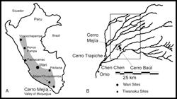
Cerro Mejía, a Wari subsidiary, are
located within a visible range of Moquegua Tiwanaku sites (Owen 1994).
Archaeological evidence for a relationship of conflict, or competition, should
show occupation by Tiwanaku first and forceful invasion by Wari, and/or similar
types and specific resources used by both
Above image of Moquegua Valley from atlantisonline.smfforfree2.com; courtesy of Donna Nash
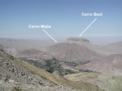
polities (Owen 1994). A relationship
of diplomatic coexistence would show evidence of a difference in types of
resources and a distinction in types of locations
(Owen 1994). The limited amount of
Tiwanaku style ceramics found at Cerro Baúl and Cerro Mejía suggest that
Tiwanaku occupation before the Wari arrived was transitory (Owen 1994). Analysis
of Wari ceramics
Above image of the visibility of Cerro Baúl and Cerro Mejía from archive.archaeology.org:courtesy of Donna Nash
found at Cerro Baúl and Tiwanaku ceramics found at Chen Chen,
a Tiwanaku site located within the Moquegua Valley, show distinct chemical
compositions that differ from each other (Sharratt et al. 2009). Comparisons of the clays
used to produce Wari and Tiwanaku ceramics found at these sites intimate that
potters acquired their clay from different sources (Sharratt et al. 2009).
Potters from Cerro Baúl employed clay that originated in the highlands from the
Huallilas Formation, while potters from Chen Chen employed clay that originated
from the middle area of the valley (Sharrat et al. 2009). Acquisition of clay
by Wari and Tiwanaku potters was a process that was limited to their particular
local territories, which maintained the boundaries of each polity and refrained
from creating a competition for resources. Tiwanaku inspired architectural elements found
at Cerro Baúl also show evidence of interaction and contact between the two
polities. Three complexes located on the flanks of Cerro Baúl were constructed
in a fashion that shares architectural design similar to Tiwanaku structures
(Nash and Williams 2005). The structures may have been an act of diplomacy between Wari
and Tiwanaku relations or Tiwanaku –related settlements that were dependent on
resources provided by Wari agriculture and administration (Nash and Williams
2005).
Archaeological evidence found on the Wari/Tiwanaku frontier does not seem to support a conflict or competition relationship between the Wari and Tiwanaku polities. Tiwanaku occupation of Cerro Baúl and Cerro Mejía was transitory, at best, with no signs forceful invasion by the Wari. Procurement of resources by both polities was a practice that remained local and did not appear to infringe upon the other polity. There is no archaeological evidence for defensible sites within the Tiwanaku area of the valley, and limited structures found at Cerro Baúl show Tiwanaku architectural elements. Analysis of the archaeological evidence suggests that the most likely relationship for the polities of Wari and Tiwanaku is one of a diplomatic coexistence. It would seem that the two great polities of the Middle Horizon expanded and flourished without violence and warfare, but coexisted rather peacefully and may have influenced one another.
Archaeological evidence found on the Wari/Tiwanaku frontier does not seem to support a conflict or competition relationship between the Wari and Tiwanaku polities. Tiwanaku occupation of Cerro Baúl and Cerro Mejía was transitory, at best, with no signs forceful invasion by the Wari. Procurement of resources by both polities was a practice that remained local and did not appear to infringe upon the other polity. There is no archaeological evidence for defensible sites within the Tiwanaku area of the valley, and limited structures found at Cerro Baúl show Tiwanaku architectural elements. Analysis of the archaeological evidence suggests that the most likely relationship for the polities of Wari and Tiwanaku is one of a diplomatic coexistence. It would seem that the two great polities of the Middle Horizon expanded and flourished without violence and warfare, but coexisted rather peacefully and may have influenced one another.
Works Cited
Isbell, W., & Vranich, A. (2004). Experiencing
the Cities of Wari and Tiwanaku. edited by Helain Siverman, Andean
Archaeology (pp. 167-182). New York: Blackwell.
Janusek, J. (2005). Residential Diversity and the
Rise of Complexity in Tiwanaku. In A. C. edited by Charles Stanish, Amanda
Cohen, and Mark Aldenderfer Advances in the Titicaca Basin Archaeology-1
(pp. 143-172). Cotsen Institute of Archaeology, UCLA.
Jennings, J. (2006). Core, peripheries, and regional
realities in the Middle Horizon Peru. Journal of Anthropological
Archaeology, 346-370.
Nash, D. J., & Williams, P. R. (2005).
Architecture and Power on the Wari-Tiwanaku Frontier. Archaeological Papers
of the American Anthropological Association, 151-174.
Owen, B. (1994). Were the Wari and Tiwanaku in
Conflict, Competition, or Complementary Coexistence? Survey Evidence from the
Upper Osmore Drainage, Peru. Society for American Archaeology 59th Annual
Meeting, Anaheim.
Owen, B. (2007). Rural Wari far from the Heartland:
Huamanga Ceramics from Beringa, Majes Valley, Peru. Andean Past,
287-373.
Protzen, J.-P., & Nair, S. E. (2000). On
Reconstructing Tiwanaku Architecture. Journal of the Society of
Architectural Historians, 358-371.
Sharratt, N., Golitko, M., Williams, P., &
Dussubieux, L. (2009). Ceramic Production During te Middle Horizon: Wari and
Tiwanaku Clay Procurement in the Moquegua Valley, Peru. Geoarchaeology: An
International Journal, 792-820.
Williams, P. R. (2001). Cerro Baul: A Wari Center on
the Tiwanaku Frontier. Latin American Antiquity, 67-83.
